Supporting materials
Download
Download this article as a PDF


What can the colours on a satellite map actually tell us about the air we breathe? Join us as we explore how the Copernicus Sentinel satellites detect gases such as nitrogen dioxide, and how chemistry helps us understand what’s happening in the atmosphere above us.
Have you ever wondered how scientists track invisible gases and emissions like nitrogen dioxide (NO2) and carbon dioxide (CO2) across the planet?
Satellites from the European Space Agency (ESA) and from other national space agencies, such as the National Aeronautics and Space Administration (NASA) and the Japan Aerospace Exploration Agency (JAXA), allow us to observe the fluxes of air pollution and greenhouse gases around the Earth, and to see how these emissions are linked to human activity.
Before satellites, data came only from ground stations or airborne measurements like balloons. Today, satellite observations monitor continuously the entire globe, including very remote and usually inaccessible places, and are validated with ground measurements. Since the 1990s, ESA has been involved in tracing gases and emissions from space, although initially with research-oriented missions such as ERS-2 and Envisat. Measuring atmospheric gases from space for operational purposes and with high precision has only become possible in recent decades, thanks to technological advances.
Nowadays, the Copernicus programme, operated by ESA and the European Commission, provides an operational, continuous flow of data from different satellites, which is freely accessible to all citizens and supports policy, regulation and enforcement on a scale that is unmatched globally. This article invites students and teachers to explore the chemistry behind these gases and work with real satellite data through hands-on classroom activities.
The ESA uses satellites to monitor air pollution and greenhouse gases from space. Even the smallest changes in atmospheric gas concentrations can be detected by the Copernicus Sentinel satellites. By measuring variations as small as one part per million for carbon dioxide, satellite data enable scientists to improve climate models and provide policymakers with more accurate predictions of the impacts of rising greenhouse gas levels.[1]
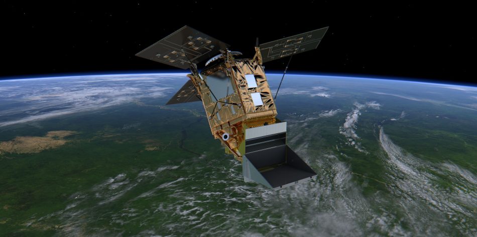
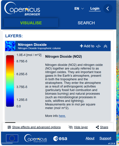
Sentinel-5 Precursor (Sentinel-5P) is the first Copernicus mission specifically dedicated to monitoring the Earth’s atmosphere (figure 1). It carries the TROPOMI instrument, which maps trace gases such as nitrogen dioxide (NO2), carbon monoxide (CO), ozone (O3) and methane (CH4) – all of which affect air quality, human health and climate.[2]
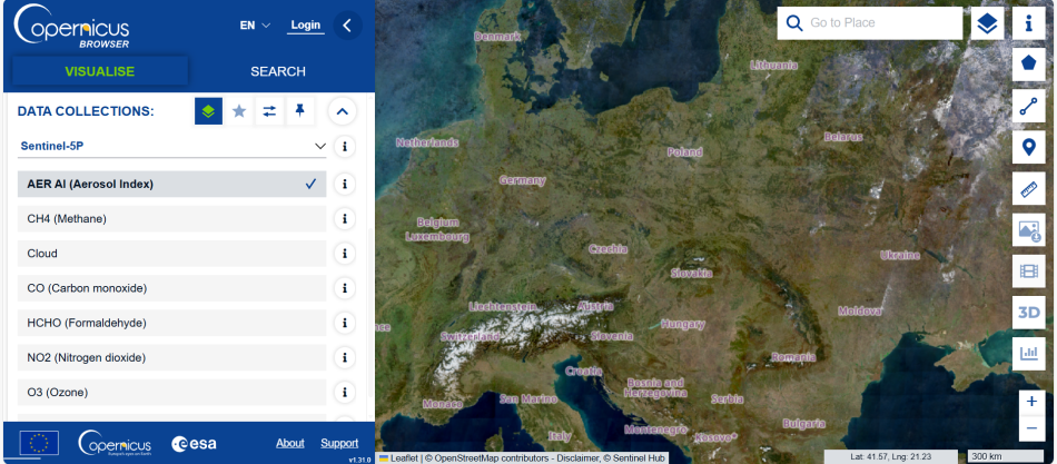
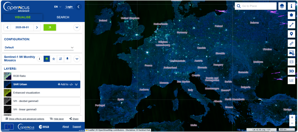
The Copernicus Browser is a free online tool that makes it possible to browse and download full-resolution images from all Copernicus missions. Through this interactive tool, you can access data from satellites such as Sentinel-5P, which monitors gases like nitrogen dioxide, and Sentinel-1, which uses radar to reveal urban areas, flooding, and land changes. You can zoom in on any location, adjust the date to see how conditions evolve over time, and compare different satellite layers side by side.
For this activity, you’ll use the Copernicus Browser to observe NO2 hotspots over cities and link them to combustion sources like traffic, power plants and industrial zones.
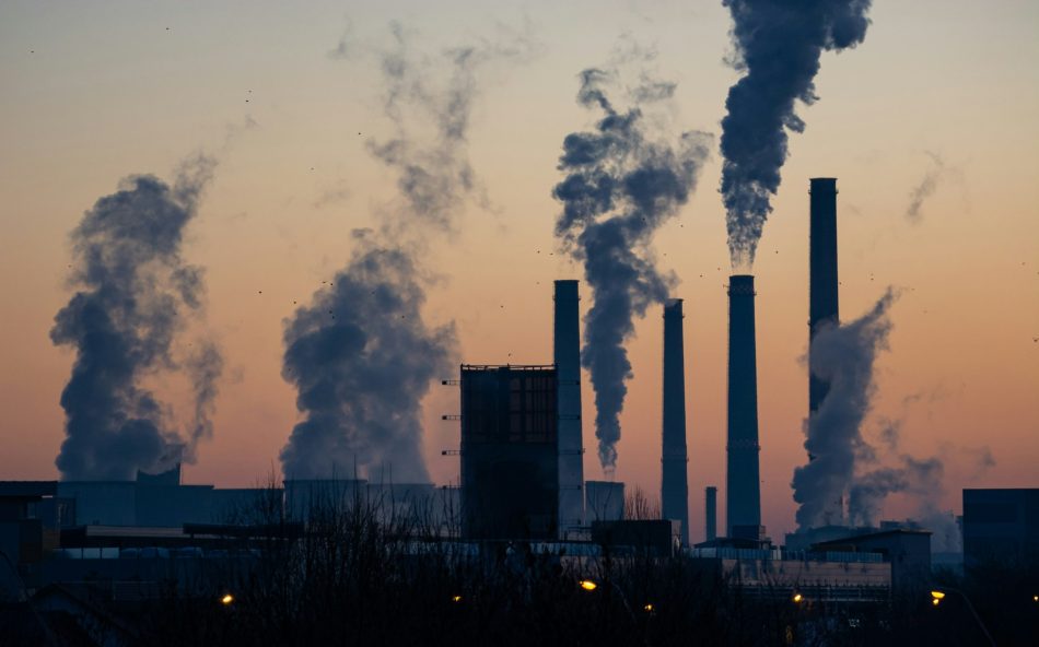
Nitrogen dioxide (NO2) is a reddish-brown gas primarily produced by burning fossil fuels in vehicles, power plants and industrial processes. As air contains 80% nitrogen, some of this nitrogen also reacts with oxygen during combustion, forming NO2. In the atmosphere, nitrogen dioxide contributes to smog, acid rain and ground-level ozone, all of which can harm human health, damage vegetation and disrupt ecosystems.
The TROPOMI instrument, on board the Sentinel-5P satellite, detects nitrogen dioxide by measuring how sunlight is absorbed and scattered as it passes through the Earth’s atmosphere. Since each gas absorbs specific wavelengths of sunlight, TROPOMI can precisely identify and map NO2 concentrations around the globe every day, with spatial resolution of about 3.5 km × 5.5 km per pixel.
Carbon dioxide (CO2) is naturally present in the atmosphere through processes such as respiration, volcanic activity, and the carbon cycle. However, human activities, such as fossil fuel combustion, have caused a dramatic increase in CO2 levels. Since the Industrial Revolution, atmospheric CO2 has risen by about 50% – an unprecedented increase in hundreds of thousands of years. Satellite observations clearly show this steady upward trend, confirming the link between human activity and climate change.
While Sentinel-5P does not directly measure CO2, it can infer CO2 emissions with limited accuracy by detecting combustion-related gases such as CO and NO2 by using ratios of these two emitted gases.[3] Therefore, this method is mainly used for rough estimates and to locate places where gases are emitted. Using these indirect measures to estimate CO2 emissions requires careful modelling to minimise uncertainties.[4]
NASA’s OCO2 and OCO3 missions measure CO2 directly. One of the first dedicated CO2 measuring satellites was JAXA’s GOSAT. Europe’s upcoming CO2 Monitoring Mission (CO2M), launching in 2027 as part of the Copernicus Expansion Programme, will provide high precision, direct CO2 observations to better track human-driven emissions. Worldwide, space agencies and industry continue to develop new technologies to improve the accuracy and validation of atmospheric measurements and data.
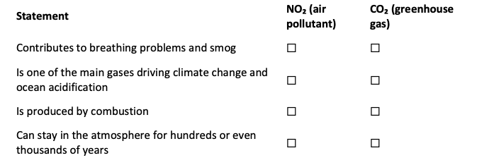
Begin the lesson by exploring air pollution, the factors that drive climate change and how satellite data helps us monitor them. Then ask students answer yes or no to a series of statements to assess what they already know (Activity 1 worksheet):
Note: For background information on how to use Copernicus Broswer, check the Copernicus Browser teacher guide.

Ask your students the following questions:
Note: These questions are aimed to spark a debate. Encourage your students to discuss what they think between each other and to access the internet if it can be useful.
Answers to the questions are provided in the activity 2 answers sheet.
Select a different map (excluding NO2) to investigate the factors that may contribute to higher emissions in these areas of Europe.
Hint: Urban and industrial areas often coincide with NO2 hotspots.
Note: Encourage students to explore different datasets and notice which types of landscapes or human-made structures, such as cities, industrial areas or highways, correspond with pollution hotspots.
To access these maps:
Are there any chemical reactions involved in the production of NO2 and of CO2? Fill in the blanks in activity 4 worksheet.
Formation of nitrogen dioxide:

Formation of carbon dioxide:

Answers:
When we look at Sentinel-5P NO2 maps, we’re seeing the chemical footprints of combustion: the burning of fuels in cars, factories, and power plants.
At high temperatures, nitrogen (N2) and oxygen (O2) react to form nitric oxide (NO), which then reacts further to form nitrogen dioxide (NO2):

That’s why Sentinel-5P often detects NO2 hotspots over busy cities and industrial regions, which mark areas of intense fuel burning and traffic activity.
But NO2 isn’t the only gas formed during combustion. When carbon-containing fuels, like methane (CH4), petrol, gas or coal, burn, the carbon (C) reacts with oxygen to form carbon dioxide (CO2) and water vapour (H2O):

This process releases energy but also contributes to greenhouse gas emissions, playing a major role in climate change.
So, every bright NO2 region in a Sentinel-5P map tells a larger story: the chemistry of combustion connects the air we breathe with the climate we share, and satellites help us see and better understand that link from space.
These questions encourage students to connect the science of combustion and atmospheric chemistry with real-world environmental and health issues, using satellite data as a tool to understand and visualise the impacts.
[1] The importance of satellite-derived greenhouse data: https://climate.esa.int/en/Scientific-highlights/Mapping-greenhouse-gases-from-space
[2] The Sentinel-5P Mssion: https://www.esa.int/Applications/Observing_the_Earth/Copernicus/Sentinel-5P
[3] Chen J, Balamurugan V (2025) Assessing the Capability of Sentinel-5P (TROPOMI) NO₂ Measurements to Monitor Point Source CO2 Emissions. EGU General Assembly 2025. doi: 10.5194/egusphere-egu25-18869
[4] Meier S et al. (2024) A lightweight NO2-to-NOx conversion model for quantifying NOx emissions of point sources from NO2 satellite observations. Atmos. Chem. Phys. 24: 7667–7686. doi: 10.5194/acp-24-7667-2024
The article on tracking air pollution using satellites combines a scientific view of the combustion processes and the spread of air pollution with the concept of sustainability, which considers the impact of local actions on global processes. In particular, the use and visualisation of current, real-time data makes the activities exciting and relevant for the students.
Wolfgang Viewer, European Southern Observatory, Germany

Did you realise that fireworks cause measurable air pollution? Tim Harrison and Dudley Shallcross from Bristol University, UK, explain how to…


Aeolus – a new laser-equipped satellite – is designed to give meteorologists the comprehensive wind data they need for better weather…


Did you know that carbon dioxide dissolves in bodies of water and affects the ocean? Explore the effect of carbon dioxide on ocean chemistry with…

