
Graphing stories
Sketch graphs from ‘story’ videos of everyday events to help students understand the basic features of graphs and how to interpret…
General science, Mathematics, Physics


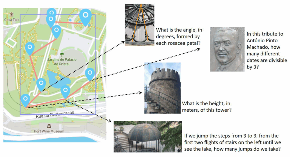
A maths field trip? Yes, really! MathCityMap transforms any space outside the classroom into an outdoor mathematical laboratory.
Imagine turning a simple city walk into an engaging mathematical adventure. MathCityMap, a free application developed by Goethe University, Frankfurt, makes this possible by converting any urban space into an outdoor mathematical laboratory where students discover and solve mathematical problems based on real objects and situations.
The growing need to innovate pedagogical practices in mathematics education has led educators and researchers to explore new methodologies to make this subject more attractive and comprehensible for students. The theory of situated learning, developed by Lave and Wenger (1991),[1] emphasizes the importance of context in knowledge construction: learning occurs more effectively when students engage in authentic activities embedded in real and meaningful contexts. Furthermore, outdoor learning, which recognizes the educational value of spaces outside the classroom, can promote both knowledge acquisition and the development of social, emotional, and physical competencies. Rickinson et al. (2004).[2] In the context of mathematics education, allowing students to observe, measure, and calculate elements present in the real environment gives tangibility to abstract concepts.
The MathCityMap application transforms any space outside the classroom into an outdoor mathematical laboratory. The combination of mobile technology, urban exploration, and mathematical problem solving allows students to discover and solve mathematical tasks based on real objects and situations present in their urban environment.
MathCityMap is a free digital platform that allows the creation, sharing, and solving of urban mathematical trails. The application works on mobile devices equipped with GPS, guiding users through predefined routes where they must solve mathematical tasks based on real elements of the urban environment.
Its main functionalities include:
MathCityMap allows the creation of trails adapted to the specific characteristics of each student group: their knowledge level, learning pace, and particular interests. This flexibility enables a more personalized and inclusive approach to mathematics education.
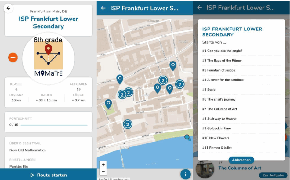
For teachers wanting to try this innovative tool, the first step is simple: download the free MathCityMap application on a smartphone or tablet. No initial registration is required to explore the basic functionalities. Inside, teachers will find an intuitive interface with an interactive map showing the current location and potential mathematical trails in the area.
The application offers several starting options: teachers can search for existing trails in their city, create their own personalized routes, or adapt available trails to their students’ specific needs. Trails can be filtered by age range, duration, difficulty level, and specific mathematical topics, making it easy to select the most suitable experience.
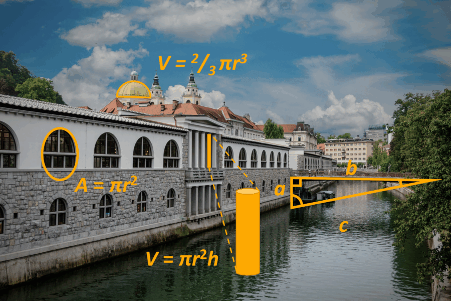
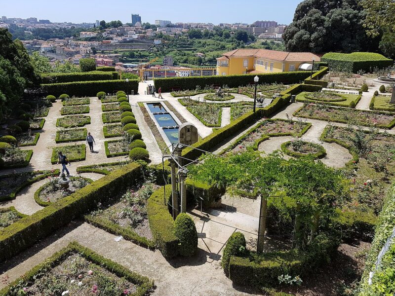
MathCityMap offers a variety of mathematical activities. Students can measure building heights using trigonometry, calculate the areas and perimeters of squares and gardens, estimate volumes of fountains or sculptures, analyze geometric patterns in architecture, solve proportion problems using urban elements, or calculate distances and speeds on real routes. Each task promotes mathematical skills, critical observation, and connection with local heritage. For example, on a trail through the Crystal Palace Gardens in Porto, students might calculate the number of tiles on a historic wall, determine the area of a circular flower bed, or estimate the height of a centenary tree.
During a typical MathCityMap session, students work in small groups, each with a mobile device. Each task follows a clear structure: students arrive at a specific point marked on the GPS map, view the mathematical task related to the object or location, access progressive hints if needed, enter the answer in the application, and receive immediate feedback on their solution. The teacher can choose close accompaniment or allow greater autonomy, depending on the students’ age and maturity.
Teachers can create their own trails using the MathCityMap web portal. The process is intuitive: they select points of interest on the map, create relevant mathematical tasks for each location, define hints and accepted answers, and test the trail before making it available to students. This functionality allows perfect adaptation of activities to a national curriculum and local specificities.
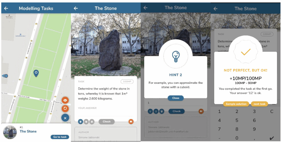
The tool supports different types of answers: exact numerical, answers with tolerance intervals, multiple choice, or open answers requiring manual validation by the teacher. This offers the flexibility to create tasks with varying complexity levels and types of mathematical thinking.
MathCityMap can be easily adapted to different teaching levels, from primary school to secondary education. For younger students, activities focus on basic concepts like counting, simple geometric shapes, and direct measurements. For more advanced students, tasks may involve differential calculus, applied statistics, or complex mathematical modelling.
While any teacher can use MathCityMap individually, implementation is particularly effective when adopted at the school or district level. Trails can be adapted to the local environment and institutional curriculum, teacher teams trained in tool usage, and a library of shared resources developed.
Our experience at Rodrigues de Freitas School Cluster in Porto (six schools located in Porto, Portugal) demonstrates how to leverage local architectural and urban richness to create authentic mathematical laboratories. The location benefits from an urban environment rich in architectural, historical, and geometric elements that naturally lend themselves to mathematical trails.
The implementation followed a phased approach, starting with teacher training, followed by creation of pilot trails, and subsequently implementation in classes from different educational cycles. The trails were designed by the teachers, based on curricular content for each grade level, from basic geometry and measurement concepts in primary education to more advanced topics like trigonometry and functions in secondary education.
MathCityMap implementation at the school cluster revealed an increase in student motivation towards mathematics. The playful and exploratory character of the application, combined with mobile technology use, captured students’ interest and promoted active involvement in the learning process.
Despite its potential, MathCityMap implementation presents some challenges that must be considered:
Despite these challenges, experience shows that the benefits far outweigh the difficulties, especially with careful planning and institutional support.
Beyond specific mathematical content, MathCityMap develops essential transferable skills: digital literacy through mobile technology use, collaboration and teamwork, critical thinking and problem solving, spatial and geographical orientation skills, and learning autonomy. The possibility of solving mathematical problems based on real and familiar elements allows students to establish connections between theoretical concepts and practical applications, developing a deeper understanding of the utility and relevance of mathematics in daily life.
MathCityMap also incorporates the principles of STEAM (Science, Technology, Engineering, Arts, Mathematics) teaching, an evolution of the STEM model that integrates the Arts into the STEM disciplines. This interdisciplinary approach promotes creativity, critical thinking, and complex problem solving.[3] For teachers seeking to innovate and motivate their students, MathCityMap offers a practical, free, and pedagogically grounded solution to transform any urban space into a dynamic and engaging mathematical classroom.
[1] Lave J, Wenger E (1991). Situated learning: Legitimate peripheral participation. Cambridge University Press. ISBN: 978-0521423748
[2] Rickinson M. et al. (2004) A review of research on outdoor learning. National Foundation for Educational Research and King’s College London. ISBN: 1 85153 893 3
[3] An article discussing the STEAM Education Model: https://www.researchgate.net/publication/327351326_STEAM_Education_an_overview_of_creating_a_model_of_integrative_education
Sketch graphs from ‘story’ videos of everyday events to help students understand the basic features of graphs and how to interpret…
Biology, maths, and the SDGs: estimate the CO2 absorbed by a tree in the schoolyard and compare it to the CO2 emissions of a short-haul flight.
Experience data like never before! Use kirigami and participatory statistics to create low-cost, hands-on multisensory visualizations to engage and inspire.