


Up, up and away: using aircraft for atmospheric monitoring Understand article
When measuring the chemistry of the atmosphere, it helps to fly up in specially modified laboratories.
measurements
Image courtesy of Tim Harrison
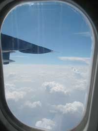
High above us, airplanes crisscross our skies – filled with families going on holiday, packages being delivered and colleagues travelling to business meetings. But for some travellers, their destination is the air around them. For the many scientists involved in climate monitoring, much of their research can only be done up in the sky.
The area from the ground up to about 10 km high comprises a layer of air known as the troposphere; beyond that is the next layer, the stratosphere. At the boundary between the troposphere and the stratosphere, air stops cooling as it rises and loses its water. In short, this is the space where clouds are created and the weather we experience begins to form. Looking out of the window of an airplane can provide a beautiful view above the clouds, but it can’t tell you much about the chemical reactions taking place or how they might affect air quality and climate. For that, you need something slightly more technical.
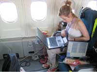
A laboratory in the sky
instruments on board
Image courtesy of Tim Harrison
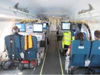
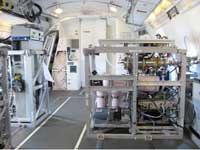
The facility for airborne atmospheric measurements (FAAM)w1, for example, is a mobile laboratory hosted in a BAe-146 aircraft, more commonly used as a small passenger jet. In FAAM, there is little luxury and no stewards or stewardesses offering drinks and refreshments. In fact, there is room for only around 10 scientists per flight. The rest of the space is filled with different pieces of equipment. Each instrument rack takes up the same amount of room as two passenger seats and they all have to be electrically and structurally secure.
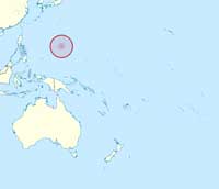
Currently based at the remote tropical island of Guam, FAAM is taking part in an international measurement campaign involving two other aircraft – the Co-ordinated Airbourne Studies in the Tropics, or CAST. This is the first co-ordinated effort to monitor atmospheric composition in the region to the south of Guam from ground level, through the troposphere and into the stratosphere, with each plane taking measurements at different altitudes. The scientists hope to improve their understanding of the tropical atmosphere and how gases move up from the surface to the stratosphere.
Pacific Ocean
Image courtesy of TUBS /
Wikimedia Commons
As FAAM flies over the Western Pacific Ocean, all the equipment inside receives samples from the air outside. These come from intakes all over the aircraft fuselage and even on the wings. Each piece of equipment measures something different, or uses a slightly different method, but together they quantify the impact of very short lived (VSL) halocarbons and how they change the complex atmospheric chemistry that affects all of us.
These compounds, such as CH3I, CH2Br2 and CH3Br, are released from the ocean and rise up into the troposphere and stratosphere, where they are broken down by light to create reactive halogen radicals. Some of these radicals will react with ozone, decomposing it, while others will react with other trace gases. Atmospheric chemistry is very complex.
Measuring molecules
Most of us are used to seeing roadside monitoring instruments in our cities. This equipment measures passing gases but doesn’t provide any information on what’s happening in the plume further downwind. Satellites, by contrast, can be used to monitor the atmosphere and provide wide spatial coverage, but they take readings of the total air column. To retrieve the profile of a specific altitude, a complex mathematical model is needed. It is therefore important to measure real data and to verify the actual concentration of compounds in a sample so that the mathematical models used can be tested and verified.
packages. Below: One of the
authors catching up on some
analysis
Images courtesy of Tim Harrison
Up in the sky, the atmospheric science researchers on FAAM use a chemical ionisation mass spectrometer (CIMS) to detect halogenated compounds as well as organic acids that are thought to promote aerosol formation, which can alter the transport of water vapour and the formation of clouds.
CIMS is used because it is both selective and sensitive. In a traditional mass spectrometer, molecules in a sample are given charge (ionised) with a beam of ions. The charged fragments are then accelerated through an electric field and their path is bent by a magnetic field before being detected, producing a complicated fragmentation pattern that relates to the charge:mass ratios of the fragments. In chemical ionisation (CI) methods, the mass spectrometer can be tuned to detect a specific molecule, or group of molecules, by using a specific ‘ionisation gas’ to create the charged particles. This produces a simpler spectrum in comparison with traditional mass spectrometry. The CIMS instrument is calibrated for every flight using known and standardised gas mixtures for the compound of interest.
Because the chemical reactivity of compounds can change with temperature and pressure, both of which change with altitude, the aircraft flies as low as 20 metres (over the sea) to as high as 10 kilometres. Flying in and out of the same area but at different heights over a 5 hour flight means that the aircraft measurements can give more spatial information than other techniques, such as sending up weather balloons. The detailed results from the expedition will help scientists refine their models and better understand just what is going on in the skies above us.
A safe landing
Back on the ground on the tiny island of Guam, the scientists stretch their legs after their long flight. Their data are downloaded from the instruments on the plane, ready to be analysed and compared to measurements taken by the other planes involved in the CAST project, as well as from equipment on the ground and in satellites far above. At the same time, the plane is refuelled and the equipment recalibrated – ready for another day of testing tomorrow. Although most comparisons of the data will be performed in the UK, the data are also used immediately by other members of the atmospheric research community, including weather forecasting services. The data may also be available to the public: in the UK, for example, much of the data produced by FAAM is publicly available on the British Atmospheric Data Centre (BADC) websitew2.
Slowly, flights like this one are helping to refine what we know about the sky above us. And, as human activities continue to alter the chemistry of the atmosphere, the findings of the scientists in the sky can help inform and advise governments across the world, which in turn will affect all of our lives.
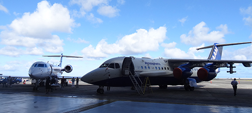
Image courtesy of the CAST team at Cambridge University, UK
Web References
- w1 – The Facility for Airborne Atmospheric Measurements (FAAM) is an aircraft measurement platform for the UK atmospheric science community, particularly scientists employed by the Met Office or working in universities funded by the Natural Environment Research Council. Their site lists core instruments and the species measured.
- w2 – To learn more about the British Atmospheric Data Centre (BADC), visit: http://badc.nerc.ac.uk/
Resources
- The Manchester team in Guam created a blog to document their trip.
- Climate change and global warming are ‘hot’ topics and deserve an important place in the school science curriculum. You can help your students to make their own predictions of climate change using this article on climate change modelling:
- Shallcross D. and Harrison T. (2008) Climate change modelling in the classroom. Science in School, 9:28-33.
- To understand how our understanding of the atmosphere has developed since the hole in the ozone layer was first discovered, visit:
- Shallcross D. and Harrison T. (2010) A hole in the sky. Science in School 17: 46-53.
- An educational webpage on bromine halocarbons and ozone layer is provided by the US Department of Energy’s ARM Climate Research Facility
Review
When we think of a research laboratory, we imagine a spacious room where people dressed in lab coats move around instruments and benches.
This is not the case for the researchers described in this article, in which the authors provide an insight into a new way of studying our atmosphere and its phenomena.
Although the location is unusual, the object of the research and its relevance are clearly described in plain language and appropriate detail for science teachers and students.
I recommend this article to secondary-school teachers and students interested in environmental sciences and in the methods used to collect data for developing climate models.
Following the release of the 5th Assessment Report by the International Panel on Climate Change, this article is an original and valuable resource to address climate problems in the classroom.
Giulia Realdon, Italy